Rocklogger for iPhone


Rocklogger is now available for iPhone!

What’s new

  • New icon
  • New bottom tab navigation to switch between records, map and stereonet view when interpreting a log
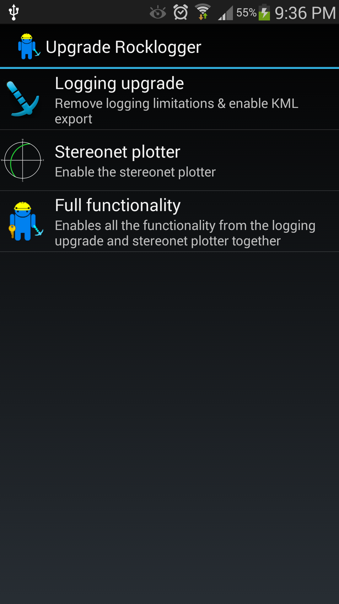
  • In-app purchases to unlock logging upgrade and stereonet features separately, without needing to purchase a separate unlocker app


What’s the same as Android

  • Same CSV format. Log files can be exchanged between iOS and Android versions, and therefore will be compatible with your existing import workflow into MapInfo etc
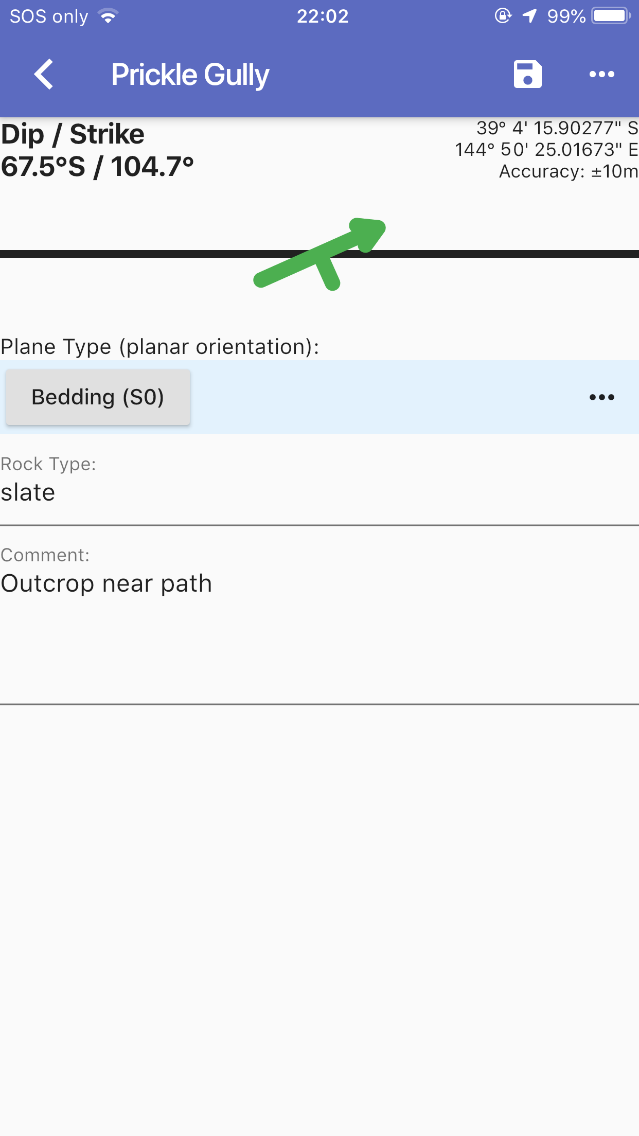
  • Logging is virtually identical, both functionally and visually
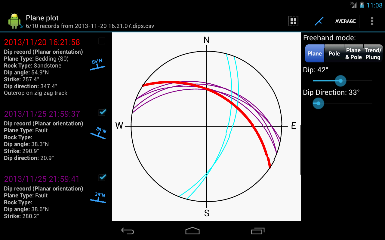
  • Stereonet is also virtually identical


What’s next

  • Custom basemaps
  • Custom log fields
  • KML export

Free download


Posted in Uncategorized | Leave a comment

New app: Connected Timer synchronises timers across nearby devices

create timetable countdown on many

Connected Timer lets you create a timetable with named intervals, and have it count down on multiple devices at once.

Create the timetable and enter each interval and duration. Then, join the timetable on other devices by running the app, and selecting the timetable when it appears. Start the timetable from any device, and they will all count down together.

You could use it to:

  • Run concurrent one-on-one interviews or exams with multiple stations
  • Set up intervals for team fitness training
  • Co-ordinate a round robin tournament

Connected Timer uses Nearby services to discover timetables on devices that are within earshot. Once the device has joined the timetable, Nearby is no longer needed and the countdowns will continue if the devices are moved apart.

Upgrade to:

  • Pause and resume across all devices in the countdown
  • Message all devices in the countdown
  • Reuse timetables from recent history

Connected Timer

Get it on Google Play

Posted in Uncategorized | Leave a comment

Bus Finder runners up in VicTripathon competition

ic_launcher  Get it on Google Play

Bus Finder is an Android app which aims to make Melbourne (and regional Victorian) bus routes easier to find. It received runners up in the 2015 VicTripathon competition, for best improvement to user experience (any PTV dataset). VicTripathon was a Victorian transit app incubator, run by CODE FOR AUSTRALIACOLLABFORGENICTAOPEN KNOWLEDGE AUSTRALIA & OWL VENTURES in collaboration with PTV.

Foo

The competition entry is here.

Posted in Uncategorized | Leave a comment

Rocklogger Updated to 1.95

Phone sensors sent to watchThis update introduces a new Android Wear companion app. It allows you to log remotely from either your phone or your watch, using the sensors in either.

The image on the left shows the apps connected to each other and logging in dip/strike mode. The white phone & watch icon (below the GPS location on the phone, and below the strike line on on the watch) indicates which sensors are being used. In this case, the phone sensors are being relayed on the watch.

You can switch sensors from the menu button -> ‘Remote Logging Mode’ on the phone (hidden if your watch isn’t currently paired), or by swiping right on the watch. From this menu you can also use voice recognition to remotely change the rock type or log comment.

You can save the record from either device, and the record will be stored in the current log file on the phone as normal.

When logging on your phone, the wear app starts automatically. You can also start logging from your watch – change the remote mode to launch the app on your phone.

If you prefer logging with the stereonet, the wear app shows it too:

Round watch showing stereonet

If you don’t have a Wear watch, you can also log remotely using a wired headset button to trigger the save.

Note: the free version of Rocklogger demos this functionality, but you need to upgrade to be able to save records.

Posted in Uncategorized | Leave a comment

Adding custom basemaps to Rocklogger

The latest Rocklogger update allows paid users to plot logs on custom basemaps. This post is a brief guide on how to get maps from several different sources onto your phone.

Use your own custom basemaps

You can plot Rocklogger records on your own maps created in MapInfo or any mapping program that exports GeoTIFF, or other common formats such as MrSID, ECW, JPEG2000, Erdas HFA, NOAA BSB etc.

  1. Export your map (GeoTIFF is the preferred format, as it retains coordinate information).
  2. Slice the map into tiles. The free MapTiler.org program creates a hierarchical directory of z/x/y .png files, which is all Rocklogger needs (choose Google Maps compatible). Other options are the paid MapTiler.com or MAPC2MAPC , which can also export in MapBox or RMaps format, and can join multiple input files together.
  3. Copy the result to your phone.
  4. Add the layer in Rocklogger. If you chose MapBox or RMaps as the output, just go Add new layer->MapBox/RMaps and select the file. Otherwise, from Add new layer choose File, and point Rocklogger to the root directory that you copied.
  5. MapTiler uses the TMS specification, meaning tile Y values increase from south to north rather than north to south, so you need to check the Flip Y axis box when adding the layer. More information. In general, if you can’t find the basemap after importing, try checking this box.

Using web map tiles

You can add maps from any site that serves web map tiles. In Rocklogger, go Add new layer->URL, and enter a url with {z}, {x} and {y} parameters. Examples include:

Creating offline web maps

You can save web maps to a MapBox file for offline use using Mobile Atlas Creator. This tool allows you to choose the map source from a predefined list, and download all tiles for the area and zoom levels you choose. You can then add the layer in Rocklogger via Add new layer->MapBox/RMaps and select the MapBox file. You will need to check Flip Y axis for these too.

Other sources

  • Geological Survey of New South Wales geological maps  (1:25000, 1:50000, 1:100000 and 1:250000 scale RMaps format, uncheck Flip Y axis)
Posted in Uncategorized | Leave a comment

Rocklogger Updated to 1.9

This update introduces the ability to plot records on custom basemaps, which you can load from a number of sources (paid only):
-Web map tiles, eg Open Street Maps
-MapBox/RMaps database
-Hierarchical z/x/y directory of tile images
-Zip file of the same directory structure

Edit: See Adding custom basemaps to Rocklogger for details

You can also send log files via NFC from the map, stereonet and edit screens, which is useful eg to send logs to a tablet for easier interpretation while offline. If there are photos in the log, they are transferred via Android Beam (using Bluetooth), otherwise the log file itself is transferred instantly.

Full changes:

-v1.9 27-01-13

-Plot logs on alternate basemaps from various sources including MapBox, zip files and the web (paid only)
-Share logs via NFC from map, stereonet and edit screens (useful when offline)
Posted in Uncategorized | Leave a comment

Rocklogger on Blackberry

Rocklogger has just been published to Blackberry World. Most features are the same as for Android, with a couple of differences:

The Android robot in the icon has been replaced by a blue symbol man:

blackberry_480

And the separate unlocker app has been replaced with in-app purchasing:

iap_bb

This allows you to activate just the feature you need, directly within the app. The current features are:

  • Logging upgrade, to remove the logging restrictions and export KML
  • Stereonet plotter
  • Full functionality, enables both features together

There’s also improvements to the Stereonet plotter on tablet (although there’s only one BlackBerry tablet, the PlayBook):

See the records and the plot at the same time, and tap to remove the ones you don't need

See the records and the plot at the same time, and tap to remove the ones you don’t need

An update for Android will be published in the next few weeks, with some new tablet layouts and other requested features.

Posted in Uncategorized | Leave a comment

Rocklogger updated to 1.6

This update lets paid users display a live stereonet plot while logging (either in addition to, or instead of the normal dip/strike symbol). It plots as a pole or plane depending on the plane type (orientation logging mode). The normal orientation mode has been renamed to planar, but axial is still the same. This orientation is now also included in the CSV file. The plane type/orientation also changes how records are plotted in the main stereonet plotter.
There are also some improvements to the stereonet plotter UI, as well as the ability to import as well as export from the GMail & Google Drive apps (and others).

Full changes:

-v1.6 21-06-12
-Renamed the normal orientation logging mode to planar.
This orientation is now included in the CSV, in the format planar:<planetype> or axial:<planetype>
-Added the option to display a live stereonet plot while logging. Displays as a plane when logging in planar orientation mode, and as a pole when in axial (paid only)
-Improvements to the stereonet UI, including better freehand plot buttons, plotting of the average by default, and warning messages when attempting to plot conflicting plane types
-You can now import logs directly from the GMail or Google Drive app (must have extension ‘.dips.csv‘). You can also send records to Goolge Drive
via the ‘Send log’ function in Rocklogger (renamed from ‘Email log’)
-Saving using the last known location will try the GPS location if the fix is less than 1 hour old, then try the Network location if it is less than 15 minutes old
-Phone now vibrates to alert when a GPS fix is first found

Posted in Uncategorized | Leave a comment

Rocklogger updated to v1.5

A new version of Rocklogger has been published to the Play Store. This update fixes a few problems when logging with the screen facing down, and also fixes the dip symbol display on tablets.

Additionally, the sale has been extended to April 27!

Full update details:

v1.5 22-4-12

  • Changed the behaviour when logging with the screen down in axial mode. Dip direction is now always the down direction. This also affects the cardinal shown in dip & strike axial modes. Note that the symbol always correctly indicated the direction that was being recorded.
  • Fixed a bug when logging with the screen down in dip & strike normal mode. Previously, when the screen was down the strike did not flip to match what was indicated by the red arrow.
    • Additionally, the dip direction cardinal letter would indicate the direction 90° anti-clockwise from the strike (when viewed from above). This was 180° opposite to the direction the phone was actually dipping (as indicated by the symbol).
    • Now, the strike flips correctly to match the red arrow, and the dip direction cardinal letter always indicates the direction 90° clockwise from the strike (when viewed from above).
  • Fixed the same problem when logging with the screen down in dip & dip direction mode. Previously, when the screen was down the dip direction did not flip to match what was indicated by the vertical line in the red symbol (ie, down), and was instead 180° opposite. Now, the dip direction flips correctly and matches the symbol.
Other changes:
  • Added the word “Overturned” to the description of overturned records.
  • Added the option to display coordinates in UTM. Records are still saved in lat/lon, as that is the format given by the GPS.
  • Further fixes for the dip symbol display on tablets
  • Increased the length of time the save toast is displayed when logging
Posted in Uncategorized | Leave a comment

Rocklogger’s birthday!

Rocklogger is now 1 year old! The first version was uploaded to the Android Market (now the ambiguously-titled Play Store) on 14th March 2011. Since then, Rocklogger has been downloaded over 8,000 times! Who would have thought there’d be so many geos with an Android phone?

To celebrate, the Unlocker is now half price in the market/store, for the next 2 weeks! After that, pricing in the different currencies will be adjusted a little to account for changes in the exchange rate over the past year (against the Australian price of AUD$9).

Thankyou to everyone who has contributed bugs and feature requests! I will continue to support and update the app in my spare time, when I’m not at my new job – making apps!

Posted in Uncategorized | Leave a comment